As a retired weatherman... 12 years USAF and 30 years NWS.. I am bias.. Ill take the weather.gov site first...Although I must say that Mikes weather page is good...He uses and mentions the NHC on his site.. I take a team effort behind the forecast...and there are a lot behind the scenes working on a forecast..I don’t care….
I am not perfect either.
And seriously I go to the NHC first… Then the NCEP model page… Then to another page to look at the other models. Then I go back to the NHC.
They are not infallible or perfect….
IT’s information… Not ordered perfection.
It’s model interpretation… Not perfection either…
You are using an out of date browser. It may not display this or other websites correctly.
You should upgrade or use an alternative browser.
You should upgrade or use an alternative browser.
New Hurricane possibly forming (Lee)
- Thread starter 97K15004WD
- Start date
I agree hrv…. I am grateful for you service to this nation. My father was in the Air Force too.
They really, really do a very, very good job.
I have a whole, whole lot of respect for the NHC, WPC and SPC and local NWS offices.
And I will say in the last 5 years during hurricane season I have been very, very glad to see the extremely talented people at the NHC use their own judgment and intuition when it comes to the intensity forecasting.
As a retired weatherman... 12 years USAF and 30 years NWS.. I am bias.. Ill take the weather.gov site first...Although I must say that Mikes weather page is good...He uses and mentions the NHC on his site.. I take a team effort behind the forecast...and there are a lot behind the scenes working on a forecast..
Absolutely a big team effort there…
I know… I have learned many of their last names in the forecast discussions past 20 plus years. Plus like you stated there are a good number of others whose names do t appear on those discussions.
Whatever happens days 4-12 prior to a hurricane hitting land is not of the highest importance. It is very necessary , helpful and key to know certain data about the storm.
The NHC has been 100 percent of the time perfect in terms of making the dangerous hazards known about in the hurricane warning area when a category 2 or stronger storm is approaching landfall within 2-3 days of landfall. I will add Hurricane Ike and Isabel while both category 2s had very strong impacts when they hit.
Extremely well done in how well articulated the danger of a storm like that presents once it gets closer to hitting land.
I can say that with what I read when Hurricane Isabel was approaching the NC and VA coastal areas. Amazingly well done.
Since that event in 2003 I have read how great a job they do every single time when a major hurricane has been approaching the coastline. One hundred percent of the time with every major hurricane hitting. Even before the internet the NHC was perfect with the major hurricanes in the 1980s and 1990s… Hurricane Elaine in 1985, Hugo in 1989, Andrew in 1992 etc etc.
Now that aspect is where the real rubber hits the road so to speak.
Whatever happens 4-12 days prior to landfall is not aa important as that.
Last edited:
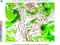
This is day 6 ahead in forecast time… Strong cold front moving east and strong high pressure moving into the upper Midwest and ridging east and south causing a deep digging trough in eastern US during this time day 6 through day 8 appears to be what recurves that hurricane out to sea.
A extremely similar pattern that did the same thing to the previous major Hurricane Franklin. Timing is a huge factor in these circumstances.
Time will tell if that pans out.
A extremely similar pattern that did the same thing to the previous major Hurricane Franklin. Timing is a huge factor in these circumstances.
Time will tell if that pans out.
Attachments
Last edited:
Interesting to note the GFS has been steadily building a strong ridge of high pressure northeast of the hurricane from Greenland by day 7 and day 8 and into day 9 combined with the high pressure to the west in NY state to retrograde southwest and opening a weakness between the two high pressure ridges. According to the GFS it would push this storm left into Rhode Island and Massachusetts…. The last 12- 14 computer model runs have been trending this way. And it was a slow trend to start with which gives this a bit more possibility to it being worthy of to take more serious note of.
Don’t know about that actually happening. The GFS model did the same sort of forecast for Franklin too. And it didn’t happen there.
But this is intriguing at the least. Time will tell.
Don’t know about that actually happening. The GFS model did the same sort of forecast for Franklin too. And it didn’t happen there.
But this is intriguing at the least. Time will tell.
Last edited:
Looks like Bermuda will have a rainy day on Thursday but no biggie. I imagine the Maritimes in Canada will be on alert this weekend. Looks like it might push water up the Bay of Fundy, already known for its high tides.

Last edited:
Totally fine if they bought the decent lids…found this old hurricane prep photo from right before Hurricane Irma... thought I would share.View attachment 177404
A possible track is New England so curious about this one. My in-laws and wife’s aunt are ocean front.
A possible track is New England so curious about this one. My in-laws and wife’s aunt are ocean front.
Yep.. That’s what I have noticed in the GFS model runs. Though the latest 1800 run has it moving east and then going left into the coast of Maine.
A far amount different than the earlier computer model runs from earlier today. Which had it actually hitting Rhode Island and Massachusetts coastal areas.
The very large day 4, 5. 6 variance in the track is due to uncertainties in the models in how the two high pressure systems act on the storm. Almost 550 nautical miles between the farthest west and east lines are definitely understandable.
Time will tell…
Last edited:
Here are the tides in the Bay of Fundy. High tide plus a storm surge would not be good.

The only interesting part was the push of the storm to the left as it moved northward. The computer model runs did that Saturday into Sunday and into Monday a bit. Which changed in the last 8 computer model runs shifted again back to the right.
But prior to that they actually had the storm moving north northeast into Nova Scotia.
Again surprisingly a decent bit accurate for being 8, 9 days ahead of time. However 550 miles or more of possible error during that time frame is understandable.
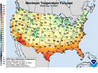
And this …. The high temperature map indicated well in advance that storm was not very likely going to hit the Florida or southeast US or Mid Atlantic coastline.
The three 10s in the Texas hold ‘em held up on the turn and river and won that pot at the table.
But there was a 20 percent chance of losing and you never know for sure until the hands are put on the table.
But prior to that they actually had the storm moving north northeast into Nova Scotia.
Again surprisingly a decent bit accurate for being 8, 9 days ahead of time. However 550 miles or more of possible error during that time frame is understandable.
And this …. The high temperature map indicated well in advance that storm was not very likely going to hit the Florida or southeast US or Mid Atlantic coastline.
The three 10s in the Texas hold ‘em held up on the turn and river and won that pot at the table.
But there was a 20 percent chance of losing and you never know for sure until the hands are put on the table.
Attachments

Last edited:
If the hurricane makes landfall in New Brunswick, it may affect the Irving Refinery in St. John, which exports most of its gasoline to the east coast of the USA. Better full up. The refinery is scheduled for a 6 week turn around starting Sept 26.
If it does it will be like a short nor-easter and not a Cat 1If the hurricane makes landfall in New Brunswick, it may affect the Irving Refinery in St. John, which exports most of its gasoline to the east coast of the USA. Better full up. The refinery is scheduled for a 6 week turn around starting Sept 26.
I noticed the media sensationalism in the photo you posted. "Near Cat 1" Noticed they didnt say Tropical storm force or gale force.
One thing for sure, anyone along the coast with a strong storm will have an issue. But they dont know where while it is still well over 1000 miles away.
I do expect possible issues for Long Island, NY Depending on track. Being the storm circulation is counter clockwise it has the potential to push water into the Long Island Bays (waterfront) This is a frequent issue, but the moon phase is mostly on their side but still close to a new moon, also depends on high tide timing. At least so far the storm is moving relatively fast and wont be sitting off the coast.
I can only assume the Refinery up there is capable of handling a storm like this. But I myself will say its way, way to soon to speculate.
Last edited:
exactly, currently Lee is projected to degrade down to TS strength and forward motion will increase the farther north it goes.. it might be one of those things where the weather sucks for a couple hours if you are in the middle and its gone before you know it
Similar threads
- Replies
- 30
- Views
- 1K