How do Airliners navigate without GPS?

Hi.
Thank you for helping me out.

'GPS signal spoofed: old school comparing raw data position ( land based radio signals….VOR/DME ) versus computed position ( GPS )'.

Is this something you would be looking at as a matter of course or only if jamming or spoofing was suspected?
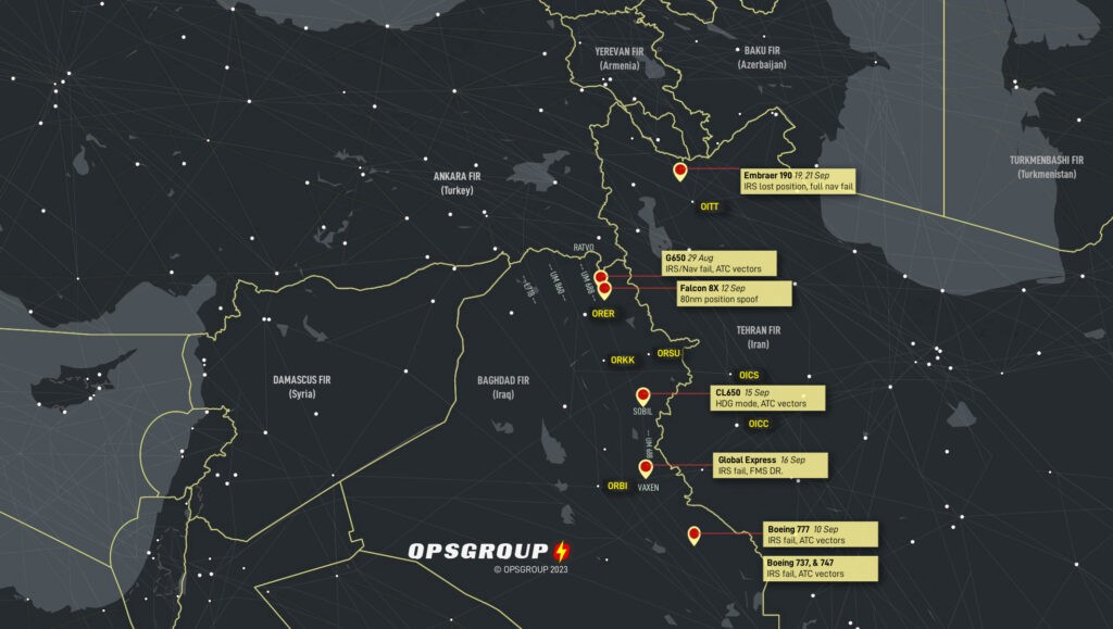
If the signal is jammed, it would be obvious and we would not use GPS ( we can deselect it ) for any approaches requiring its use. We would fly an ILS or old school VOR/DME approach ( or do a visual approach ). We would receive an alert …” GPS Primary lost”.

If the signal was spoofed, we might would receive an alert in the cockpit warning us that there is a significant difference in estimated position ( IRS versus GPS ) and an alert would be triggered ….” FM/GPS POS DISAGREE”. We would verify ( raw data ) and deselect the two GPS receivers and navigate using IRS.

Since Airbus has limited info in the manual, I hunted around for more information and this is what Honeywell says ( manufacturer of our FMS ) about spoofing.

I learned stuff myself today due to conflicting , and limited , information by Airbus ( spoofing, not jamming ).


Last edited:
I went through USAF navigator training in '74, before GPS was operational. Techniques taught included dead reckoning (knowing where you are, applying your heading, airspeed, winds aloft and time to know where you should be), observing ground references, radar navigation, celestial (sun or stars, not used much anymore), VORTAC, TACAN, LORAN (I think now decomissioned), etc, etc. When accurate and reliable inertial navigation systems came online navigators became redundant in many aircraft and positions were eliminated. GPS put the final nail in the coffin. Fortunately, my first operational assignment was as a Weapons System Operator, so I had job security.
GPS is so easy to use and reliable it's understandable why it's universally employed and other nav methods are no longer emphasized. Active jamming may force a re-evaluation, especially when it comes to weapons targeting.
 
I believe most navigation systems still have inertial navigation using gyroscopes. My wife was insistent that spoofing, jamming, or destroying GPS would mean that most air/surface to surface guided weapons systems would be useless, but I tried explaining that inertial navigation was common before GPS and they all have backups using inertial navigation. I think cruise missiles also have terrain mapping that’s programmed in to guide by spotting terrain and buildings using cameras.
 
I believe most navigation systems still have inertial navigation using gyroscopes. My wife was insistent that spoofing, jamming, or destroying GPS would mean that most air/surface to surface guided weapons systems would be useless, but I tried explaining that inertial navigation was common before GPS and they all have backups using inertial navigation. I think cruise missiles also have terrain mapping that’s programmed in to guide by spotting terrain and buildings using cameras.
But even airline pilots are being misled about spoofing.

I was 100% sure about jamming, but not spoofing until I did thorough research yesterday because Airbus doesn’t provide pilots with clear information about spoofing ( except to say it’s a problem , they monitor reports but no Airbus have been spoofed, so far ).

We use Honeywell Navigation systems and the two articles I listed previously in this thread clear it up entirely.

Many pilots will believe stuff like this article talking about how it messes with IRS ( because FMS uses hybrid GPS/IRS information ).


Here is the truth, according to Honeywell:


The only area I fly to that has GPS issues is Mexico ( jamming reports ).
 
Last edited:
But even airline pilots are being misled about spoofing.

I was 100% sure about jamming, but not spoofing until I did thorough research yesterday because Airbus doesn’t provide pilots with clear information about spoofing ( except to say it’s a problem , they monitor reports but no Airbus have been spoofed, so far ).

We use Honeywell Navigation systems and the two articles I listed previously in this thread clear it up entirely.

Many pilots will believe stuff like this article talking about how it messes with IRS ( because FMS uses hybrid GPS/IRS information ).


Here is the truth, according to Honeywell:


The only area I fly to that has GPS issues is Mexico ( jamming reports ).

GPS reprogramming was the plot of a Bond movie. Stealing a GPS encoder was part of the plot, but I don't understand why it would be so recognizable. I work in the electronics industry, and the box that electronics come in can be very different. If I were asking someone to do that kind of work, it wouldn't be fixed to a unique looking box, but would probably just be a bunch of FPGAs on a rather generic looking board going into a rather generic looking box. I wouldn't want it to be recognizable.

 
It's only recently that GPS was approved to be used within the first tier of navigation methods. There was always a mindset that it could fail at any time either unintentionally or intentionally.
 
It's only recently that GPS was approved to be used within the first tier of navigation methods. There was always a mindset that it could fail at any time either unintentionally or intentionally.
I was using GPS in 1995 for en route navigation in the high Arctic when based in Baffin Island.

Just checked my log book and my airline first started flying GPS approaches in 2008 on the A320.

IRS drifts with time and GPS is subject to atmospheric errors at times , that's why Airline navigation systems use a hybrid of both systems.
 
Last edited:
Do the airlines use grid navigation instead of lat long in the very high latitudes, or has that gone the way of the buffalo?

When I flew up there in 1995, airports in the Arctic had NDP or VOR approaches ( 2 ILS ….Iqaluit and Resolute Bay ).

I just tried to check what types of IFR approaches they use up there now but my company doesn’t have that information ( fleet I am on doesn’t go up there unlike the wide bodies that cross over up there going overseas ) on my work iPad.

Not sure what they use for approaches up there but they don’t use grid navigation.

Just did a google search…..CYRB ( Resolute Bay ….75 degrees North latitude ) has RNAV approaches so they must use them all over the arctic.
 
Last edited:
Before GPS, there was Loran within a few hundred miles of the coastline. The Military allowed civilians to use their GPS when it first came out but reserved the right to shut it off at any time.
 
There used to be 4 crew members, the Captain, 1st Officer, Engineer & Navigator.
Nav was the first to go followed by the Engineer then by 2 engines as in transoceanic flights for safety 4 engines were
required, now they say 2 are sufficient, and they are IF both are working :cool:;)
The two engines over ocean flights are laughably referred to as ETOPS flying.

Engines Turning or Passengers Swimming
 
I believe most navigation systems still have inertial navigation using gyroscopes. My wife was insistent that spoofing, jamming, or destroying GPS would mean that most air/surface to surface guided weapons systems would be useless, but I tried explaining that inertial navigation was common before GPS and they all have backups using inertial navigation. I think cruise missiles also have terrain mapping that’s programmed in to guide by spotting terrain and buildings using cameras.
It’s been a long time since they used mechanical gyroscopes. A ring laser Gyro, which has fiber optic loops and uses interferometry, has been the standard for a while.
 
It’s been a long time since they used mechanical gyroscopes. A ring laser Gyro, which has fiber optic loops and uses interferometry, has been the standard for a while.

Don’t know the details, but I was thinking more like micro-electromechanical systems (MEMS) gyros. These are found in most smartphones and tablets these days where they can be used for gaming and possibly navigation. But of course they might also know position using GPS and Wi-Fi positioning.

The big one was InvenSense, which got bought out by TDK. The examples they have in photos for their most advanced versions look like a hovering drone, an offshore oil/gas platform, a military laser designator, and a high-speed train.

Our GYPRO® digital MEMS gyroscopes feature a 24-bit digital SPI interface that speeds-up their integration compared to conventional analog sensors. The in-house factory calibration removes the need for costly and complex temperature modeling and compensation at system-level. For applications where safety matters, the digital interface integrates an initial self-test as well as a unique continuous in-operation self-test.​
Contrary to expensive and bulky solutions like FOG (Fiber Optic Gyros) and DTG (Dynamically Tuned Gyros), our high stability digital MEMS gyros are housed in a miniature hermetic SMD package that reduces the overall SWaP-C (Size, Weight, Power and Cost).​
I thought this thread was about airliners.

Not smartphones.
 
I thought this thread was about airliners.

Not smartphones.

I’m just hinting that MEMS gyros are ubiquitous and relatively cheap. And likely to replace some more expensive technologies.

 
The question was - “How do airliners navigate without GPS”. Future tech is a different subject. Ring Laser Gyro, Inertial Nav, ground based navigation aids, are part of the answer to the thread question.

Differential GPS was once touted as airliner future tech. That was 25 years ago.

Still hasn’t happened.
 
IFR (I Follow Roads)... at least that is how Bill navigated his way from
Sacramento to Oshkosh Fly In Wisconsin flying his 1930 Waco KNF... I
drove chase in his Van guided by my Garmin GPS while Bill flew
overhead NORCO (no radio)... Bill was classic old school... During WW2
he was an flight instructor (AT6 BT13 and you name it) while his
buddies Steve and Ray flew P-38s in Europe... Mercy did they have some
stories to tell...

NC698N in 1997...
BillPhelps (1a).jpg


NC689N in 1930...
BillPhelps (12).jpg
 
Back
Top