How many people still use paper maps?

I still get a copy evey year from Illinois.

 
The ring bound Thomas Guide was my go-to before Google Maps or the internet was ever invented.

Thomas Guide.jpeg
 
I still get a copy evey year from Illinois.

The IDOT maps are actually really good. Much better than, say, neighboring Indiana's.
 
If I were going out there, I'd probably buy a new one. But thanks for pointing out an obvious note.

BTW, do you think that Google/Apple/Etc have "all of the roads now" in all areas of the US?
Yes-they even have the little off -road vehicle trails that many have gotten stuck on when the Interstate was closed. There was just a story about that a few weeks ago. The road from Las Vegas to L.A. was closed due to high winds-google showed a "detour" which was the old Mojave trail. It goes from gravel to dirt to nothing. Dozens of cars followed that route and got stuck Even if you have AAA their towing does not include off road recovery.

The state contacted google and told them not to show that as a detour anymore. Sometimes you got to protect people from themselves..
 
AAA still has them for members, but things have changed a lot over the years. My local AAA member offices used to have vending machines where one swipe of a membership card allowed up to maybe 6 maps or books per day. That's gone and basically it only comes from a filing cabinet now on request.

The gold standard used to be the maps made by the California State Automobile Association, which had its own mapmaking division in San Francisco. The maps covered the membership area, which was Northern California and Nevada at the time - maybe a few other areas. They also had maps of different California even though the Auto Club of Southern California had their own maps that covered some of the same areas, which weren't anywhere near as good. Even though they closed down their cartography division, these maps were still available for some time even though they weren't updated.

 
50 and will not use a paper map if I don’t have to. Maybe a tourist map however road map nope.

Phone with area of concern downloaded into Google Maps for offline access.

I did not mind the map books that sectioned state into large pages / grid. Paper map 😂
 
I love maps. I love using them to plan our trips.

Nothing better than having them spread out flat on the dining room table.

They give me a sense of distance, elevation, geography. Also opportunity's.

Quite often I’ll divert on a back road, farm road, packed gravel/dirt road. Just to see what’s there.

It’s not unusual for me to carry 10-15 maps on a long trip.

My favorite state map is Wyoming.
 
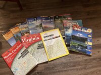
I have a bunch of them…. I actually need to get a 2024 Rand Mc Nally road atlas again… Been 3 years since I have gotten one.

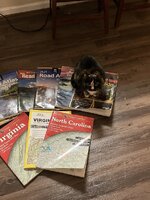
I know I have had Rand Mc Nally atlases from 1987, 1988, 1989, 1990, and the one here in this picture from 1993.

My wife and I used the 2012 one when we went 700 miles north on vacation in Vermont. I was teaching her how to read a map on that trip. She got pt good with it about 2/3 of the way while heading north to Vermont.

I had older road atlases from 1980 I think and the one from 1951 which was from my step father dad. That was in amazingly good shape and of course it was the old US route system only. Before the Eisenhower interstate system had been started.

I memorized the entire US interstate system and all 50 states and capitals by the age of 8 years old. I knew all 100 counties in Virginia and all major roads across the state.

My classmates in school were all amazed at how much I knew about all the roads across the US.
 

Attachments

  • IMG_0459.jpeg
    IMG_0459.jpeg
    203.6 KB · Views: 7
  • IMG_0454.jpeg
    IMG_0454.jpeg
    179.8 KB · Views: 7
I used to carry paper trail maps when hiking. I really liked the National Geographic maps - mostly of national parks, but also of other areas. They're paper, but plastic coated.

I remember when the USGS sold paper maps - especially the 7.5 minute quadrangles. I remember my local REI used to carry them for pretty much the entire Bay Area and some places of interest like national parks and popular hiking spots. I thought of getting one that included my hometown, but I think they stopped printing them.
 
I use paper maps because I'm a cyclist and motorcycle rider. Paper maps give me a clear view of preferable curvy, low traffic roads that make those activities more enjoyable/bang for the buck.

20200506_171440.jpg


Paper maps were all I needed to get from Ohio to the Arctic Circle and back too ;)

2003-07 AK48 Start of Dalton Hwy.JPG


2003-07 AK64 Superglide next to Arctic Circle sign 2.JPG
 
I just ordered a couple - trying to get along with my Navigation system can be stressful … especially when I don’t want to be on certain roads with special idiots …
 
I love maps. I love using them to plan our trips.

Nothing better than having them spread out flat on the dining room table.

They give me a sense of distance, elevation, geography. Also opportunity's.

Quite often I’ll divert on a back road, farm road, packed gravel/dirt road. Just to see what’s there.

It’s not unusual for me to carry 10-15 maps on a long trip.

My favorite state map is Wyoming.
you just like how we simplified are calling with one area code only, 3 oh 7 😄😄
 
Absolutely use paper maps, when planning. Not so much while driving.

Drove from Connecticut to Colorado, then Utah, California, Mexico, Arizona, Colorado, Wyoming, Idaho, Montana, and back to Connecticut across the norther tier of states in 1983 with nothing more a couple AAA “regional” maps. One for the NE, one for the NW, and a SW.

Still have detailed atlases (showing every fire road, logging road, and dirt road) for a couple states and my kids gave me a brand new Atlas for the 50 states as a Christmas gift. Real maps have their place. GPS is nice, but it lacks detail and doesn’t show the whole picture the way a map can.
 
This reminds me need to get one for our trip this year to Alaska. Overall going to start consult a paper map on trips, google maps has let me down too many times. In a RV steep grades are whole 'nother animal.
 
Let me start by saying "I do".

Whenever I plan a road trip I get paper maps of the areas I'm driving through and traveling to. A paper map aids my sense of direction, helps me visualize my progress, and shows me alternative routes should I need or choose them.
I agree with you totally.
Sadly, you can't even buy a 'Road Atlas' anymore at Walmart. I much prefer reading a map than looking at the small screen of my cell phone for the exact reasons you mention.
 
Back
Top