Hurricane Idalia - landfall in Florida

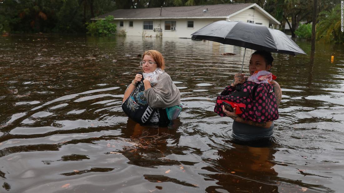
Tornadoes, preceding, tropical storm, three just reported in Charleston.
Tornadoes along the coast are not like the big ones you see out west. MOST times but not all.
On the news was just somebody with a dash cam that turned in the video to the news station of a tornado picking up the car in front of them in Charleston in mid air, flipping it sideways and landing on the side of another car😖
 
Been on the coast for many decades. This photo is 200 feet from our house. The kayak is mine.

View attachment 175852

12 feet of surge (especially coupled with a high tide) would put the water about 3 feet into our first floor.

Because of the movement of the water, the house likely wouldn’t survive. The NOAA site from which I screen grabbed the surge prediction has been remarkably accurate for us. We are quite close to the water - that’s the inland waterway in the photo, and we’re less that half a mile from the Chesapeake Bay.
My grandparents, and now 2 of my Aunts and Uncles, live(d) up in the Grafton/Yorktown area out on the Bay by where Amoco was, since 1987. The only one that actually did major damage to the house was I think Irene (?), where the main floor of the house was 7' above mean high tides and ended up with the garage with about 4' of water, and the house ended up with about 8-10" in it. As a result, nearly everything on the main floor had to come out, and they also raised the entire house 36" with new footings and beams, what a disaster. Now they're 11' above mean high tide, but anything that comes up the bay or a good Nor'easter will put the creeks well above road level out there.

Their house was one of only two on the entire point that had in-ground pools at the time, and its only via good luck that it's still in service, but it's taken the brunt of weather over the years. Nobody wants to contract work on a pool where the deep end & piping is actually below the average low tide water level!
 
Question, when a storm like this comes though, does low-high tide have any effect on the storm surge? So can the surge be even worse if storm hits at peak-just before high tide?
 
The area it hit is sparsely populated. Taylor County and Madison County where the eye passed through before entering Georgia only have a combined population of 30,000. And the area east of there down to Crystal River is thinly populated also. Insured damages there will be miniscule compared to a hit down state in the peninsula.
Glad to hear that. The news is showing areas hit pretty hard. Insurance is already ridiculously high in Florida compared to a lot of other states, the last thing Floridians need is another rate hike.
 
My grandparents, and now 2 of my Aunts and Uncles, live(d) up in the Grafton/Yorktown area out on the Bay by where Amoco was, since 1987. The only one that actually did major damage to the house was I think Irene (?), where the main floor of the house was 7' above mean high tides and ended up with the garage with about 4' of water, and the house ended up with about 8-10" in it. As a result, nearly everything on the main floor had to come out, and they also raised the entire house 36" with new footings and beams, what a disaster. Now they're 11' above mean high tide, but anything that comes up the bay or a good Nor'easter will put the creeks well above road level out there.

Their house was one of only two on the entire point that had in-ground pools at the time, and its only via good luck that it's still in service, but it's taken the brunt of weather over the years. Nobody wants to contract work on a pool where the deep end & piping is actually below the average low tide water level!

I think you are referring to Hurricane Isabel in mid-September 2003, not Hurricane Irene in 2011. I am ~12 miles from Grafton/Seaford/Yorktown and that storm was barely Category 1 when it hit the Chesapeake Bay. It stalled and dumped about 18" of rain on us in
Funny but true story... generators were impossible to find within 100 miles but Home Depot called me on the morning of Day 15 and said they just received a trailer load of 5.5K Generac units at their Kitty Hawk, N.C. store. I immediately drove 108 miles to that store and bought the Generac unit. As I returned home some 5 hours later, the stoplights and neighborhood power came back when I was 4 blocks away from my house! Just my luck! o_O
 

The center of Idalia is now moving through South Carolina​


"The sustained winds have decreased slightly and are now down to 65 mph.

Strong onshore flow is producing 2 to 5 feet of surge along the coast of the Carolinas.

Storm surge flooding will peak this evening at high tide. In Charleston, this peak will likely be in the next hour. Water levels are currently at 7.67 feet. The National Weather Service is predicting a peak of 8.7 feet which would be a top 10 level in their historic records and the highest since 2018.

In addition to the surge, heavy rain, gusty winds and the threat for tornadoes will continue into the overnight hours for eastern sections of the Carolinas."

 
Last edited:
I think you are referring to Hurricane Isabel in mid-September 2003, not Hurricane Irene in 2011. I am ~12 miles from Grafton/Seaford/Yorktown and that storm was barely Category 1 when it hit the Chesapeake Bay. It stalled and dumped about 18" of rain on us in
Funny but true story... generators were impossible to find within 100 miles but Home Depot called me on the morning of Day 15 and said they just received a trailer load of 5.5K Generac units at their Kitty Hawk, N.C. store. I immediately drove 108 miles to that store and bought the Generac unit. As I returned home some 5 hours later, the stoplights and neighborhood power came back when I was 4 blocks away from my house! Just my luck! o_O
Yes, Isabel. That’s right… while they were both still alive. Aunt & Uncle #2 lived off Dare Road. That storm was also the beginning of a shift that’s dumped thousands of gallons of sand into their channel system… Good times… thanks!
 
I think you are referring to Hurricane Isabel in mid-September 2003, not Hurricane Irene in 2011. I am ~12 miles from Grafton/Seaford/Yorktown and that storm was barely Category 1 when it hit the Chesapeake Bay. It stalled and dumped about 18" of rain on us in
Funny but true story... generators were impossible to find within 100 miles but Home Depot called me on the morning of Day 15 and said they just received a trailer load of 5.5K Generac units at their Kitty Hawk, N.C. store. I immediately drove 108 miles to that store and bought the Generac unit. As I returned home some 5 hours later, the stoplights and neighborhood power came back when I was 4 blocks away from my house! Just my luck! o_O


Actually you are right about Isabel was that stronger storm.

Though it did not stall out in the area… it moved northwest at a decent rate of speed. It hit that Thursday am and by the next am on Friday am it was clear and sunny.

The 18-24 inches of rain event your are thinking of was in fact Hurricane Floyd in September 1999. And it did not stall out in the region either, it actually tracked northeast at a good pace too. On a curved track that is typically seen with hurricanes along the east coast. What happened was it had interaction with an approaching cold front from the west.

Below is the rainfall from Hurricane Floyd.

C. RAINFALL...(STORM TOTAL FOR 9/14/99 - 9/16/99)

YORKTOWN 18.13 INCHES #

GLOUCESTER 11.25 INCHES

LOWER JAMES CITY COUNTY 12.83 INCHES

JAMES CITY COUNTY 14.30 INCHES

SMITHFIELD 12.50 INCHES

NORFOLK AIRPORT (ORF) 6.81 INCHES

HAMPTON (LFI) 7.50 INCHES

This rainfall map below is from Hurricane Isabel.
 

Attachments

  • IMG_0343.jpg
    IMG_0343.jpg
    215.1 KB · Views: 7
Last edited:
Even around here, why would you buy a house that's only 9 feet above sea level?
There are several thousand houses in Virginia Beach that face a flood risk similar to mine. Part of why the city is working on mitigation measures.

Some parts of the coast are, well, low lying. Take a look at this map. Blue dots represent streets/land that are 1-3 feet above high tide. Quite a lot of low lying land in NC, a bit in VA, and quite a lot in MD. Most of it developed.

IMG_2275.jpg


My house was built in 1996. The builder piled up six feet of dirt to raise it above the street level, then built it on a crawl space above that. It’s not 9 feet above sea level, it’s nine feet above a king tide/full high tide.

But when you combine a storm surge, with tide, you get destruction.
 
There are several thousand houses in Virginia Beach that face a flood risk similar to mine. Part of why the city is working on mitigation measures.

Some parts of the coast are, well, low lying. Take a look at this map. Blue dots represent streets/land that are 1-3 feet above high tide. Quite a lot of low lying land in NC, a bit in VA, and quite a lot in MD. Most of it developed.

View attachment 175976

My house was built in 1996. The builder piled up six feet of dirt to raise it above the street level, then built it on a crawl space above that. It’s not 9 feet above sea level, it’s nine feet above a king tide/full high tide.

But when you combine a storm surge, with tide, you get destruction.


HellYeah seriously…

9 feet is pretty darn decent. Where my grandfather lived there in Gloucester at Carmines Island it was maybe…maybe 5 feet above high tide.

During Isabel that whole island was covered in water by a 7 foot storm surge. I remember 2 older homes that faced the York River bridge… After Isabel they all were torn down and rebuilt. Now../ The tops of the roofs of those houses is as tall as a telephone pole. They are elevated at least 10 feet off the ground. Next time I go over that way I will take pictures. It’s kind of strange seeing homes tall as telephone poles.

I know where a beautiful home is up on a 40 foot hill overlooking the York River… The Mars estate that’s worth ohhh $ 45 million dollars. . That place is extremely close to where my grandfather had his home. We passed the gate for the Mars estate going to and from his place. You went down a long, long hill on the road to my grandfathers place. So you lost 30 plus feet in elevation going down that hill.
 
Even around here, why would you buy a house that's only 9 feet above sea level?
I hear you, but much of the land in SE TX is not much above 10 ft. Generally 10-20 ft. Some places 30 ft. but not much. People choose to live here because that's where the O&G industry is (jobs). It advisable to build up the elevation of the home, or elevate the home up on pilings.
 
Question, when a storm like this comes though, does low-high tide have any effect on the storm surge? So can the surge be even worse if storm hits at peak-just before high tide?
Yes, if peak surge correlates with high tide, that makes it much worse. High tide around here is 5.5 feet average. If peak storm hits high tide vs low tide, your surge can be 5.5 feet difference.

They spent a lot of money fixing the sea wall over the last couple years which has helped, but it flooded last night due to the almost nothing storm by the time it arrived because it hit at high tide. He explains it in this video - high tide part is at 25 seconds but given its only a minute long total, worth a watch if your interested.

 
HellYeah seriously…

9 feet is pretty darn decent. Where my grandfather lived there in Gloucester at Carmines Island it was maybe…maybe 5 feet above high tide.

During Isabel that whole island was covered in water by a 7 foot storm surge. I remember 2 older homes that faced the York River bridge… After Isabel they all were torn down and rebuilt. Now../ The tops of the roofs of those houses is as tall as a telephone pole. They are elevated at least 10 feet off the ground. Next time I go over that way I will take pictures. It’s kind of strange seeing homes tall as telephone poles.

I know where a beautiful home is up on a 40 foot hill overlooking the York River… The Mars estate that’s worth ohhh $ 45 million dollars. . That place is extremely close to where my grandfather had his home. We passed the gate for the Mars estate going to and from his place. You went down a long, long hill on the road to my grandfathers place. So you lost 30 plus feet in elevation going down that hill.
Interesting that my friend used 9 feet building his home at South Padre Island - did some cinder block slab riser and green board so they hope to rinse out the sand and move back in if it happens … In the meantime they walk the dogs on the beach early/late …
 
Yes, if peak surge correlates with high tide, that makes it much worse. High tide around here is 5.5 feet average. If peak storm hits high tide vs low tide, your surge can be 5.5 feet difference.

They spent a lot of money fixing the sea wall over the last couple years which has helped, but it flooded last night due to the almost nothing storm by the time it arrived because it hit at high tide. He explains it in this video - high tide part is at 25 seconds but given its only a minute long total, worth a watch if your interested.


Hurricane Hugo in 1989 was made even worse by hitting on an astronomical high tide… Maximum storm surge in that storm was near 15 feet north of where the eye made landfall.

One aspect to remember though is the shape of a local coastline is a big factor in how high or low a storm surge will be.

In Hurricane Isabel with its northwest direction it put the right front quadrant in line with the opening of the Chesapeake Bay. So winds were unabated all the way from the Atlantic Ocean to the Bay and into the York and James River.

How much affect did that have? Tides were even higher northwest in the York river with a maximum surge of 8 feet in West Point. Versus 7 feet 35 miles southeast in Yorktown and Gloucester Point.
 
  • Like
Reactions: 4WD
I hear you, but much of the land in SE TX is not much above 10 ft. Generally 10-20 ft. Some places 30 ft. but not much. People choose to live here because that's where the O&G industry is (jobs). It advisable to build up the elevation of the home, or elevate the home up on pilings.
Yeah, but I've noticed that flood prone areas normally have slab houses. I keep thinking that if they only had at least a crawl space most of them would be fine.
 
Yeah, but I've noticed that flood prone areas normally have slab houses. I keep thinking that if they only had at least a crawl space most of them would be fine.
It takes a lot more than that to make a house flood resistant. Many homes here are on pilings. They’re eight to ten feet above ground level. They’re built with flooding in mind. The pilings allow the water to move underneath the house. Even the Heat Pumps are raised up on piling.

Three feet of crawl won’t make any difference if they’re close to the ground. The ground itself needs to be raised, then a crawl, perhaps. That’s how our house was done, but it was several feet of fill, then a crawl.

Even then, a storm surge moves an incredible amount of water. That inrushing water can take out the walls of a crawlspace and wipe the house off the foundation.

Some new construction homes/condos in low lying areas feature breakaway walls and a sacrificial first floor. The drywall breaks away easily, allowing the water to flow through the studs. The first floor gets wiped out (it’s usually designed as garage/storage) but the structure survives.
 
Yeah, but I've noticed that flood prone areas normally have slab houses. I keep thinking that if they only had at least a crawl space most of them would be fine.
Hilton Head Island is a overpopulated sandbar on the South Carolina Coast. The older houses built in the 60's were on slabs, for varios reasons (damp, termites, etc). Not a great idea for hurricane's.

However the new building code is they need to be elevated. The actual amount I believe is a number above Mean High Tide. Most builders simply make the entire first floor a garage. In the pic below the garage looks enclosed, but it isn't really. The walls are wooden slats with about 1 inch space between each so the water can pass through - in theory. I have circled the slats.

There also on pilings - not stick and brick bottom floor.

1693569728043.png


1693569697623.png
 
Back
Top