Need advice for a trip to Sarasota (right on time for a hurricane)

I just put on the Weather Channel, and this thing has been downgraded to a tropical storm. It looks as if the thing is petering out.
I urge you to find another source for information. That company is a complete joke and agenda driven.

They have been outed countless times during a storm where their people are staging effects for the camera and their agenda.
Not to defend any media source but billt is just mistaken, weather channel did not report any such thing as it still isnt a hurricane as of this morning 8/28/23 so it couldn't have been downgraded. I suspect he was expecting to see Weather Channel reporting on the hurricane and by seeing it was only a Tropical storm he thought it was downgraded.

One thing for sure, better said, as of right now this is NOT going to be a major Cat. 4 or 5 and as of right now maybe a minimum 3 at worst. Too soon to know but there is significant shear for the next 24 hours that is limiting it to maybe a 3 by the time it gets to land.
Of course no one knows for sure.
 
I just put on the Weather Channel, and this thing has been downgraded to a tropical storm. It looks as if the thing is petering out.
I have doubts. It may have come across some shear but the storm will be moving over water as warm as bath water. I would believe a CAT 3 is possible before landfall.
 
Per @alarmguy post above - this is now predicted to be a Major Hurricane >110MPH. Note the "M" in the track just before it hits land.

Of course its all just a prediction and as mentioned strength is really hard to predict.

I am of the belief that the NHC cone is too narrow. far too many see the center of the track within the cone and make sweeping declarations.

The cone represents a statistical prediction that very few understand - its not an anticipated path. They don't "make" the cone larger or narrower, it represents a track the eyewall - not the storm - will stay within at about 60-70% probability - its in the fine print:


"NHC tropical cyclone forecast tracks can be in error. This forecast uncertainty is conveyed by the track forecast "cone", the solid white and stippled white areas in the graphic. The solid white area depicts the track forecast uncertainty for days 1-3 of the forecast, while the stippled area depicts the uncertainty on days 4-5. Historical data indicate that the entire 5-day path of the center of the tropical cyclone will remain within the cone about 60-70% of the time. To form the cone, a set of imaginary circles are placed along the forecast track at the 12, 24, 36, 48, 72, 96, and 120 h positions, where the size of each circle is set so that it encloses 67% of the previous five years official forecast errors. The cone is then formed by smoothly connecting the area swept out by the set of circles."


They should get rid of the cone altogether past 48 hours, issue a "watch" like they do with tornadoes. If you look at Hurricane's like Katrina - no one left because too many times they had been told to leave and nothing happened. It happened here as well - the governor shut everything down I think in around 2014 - told everyone to leave, reversed the interstates, lots left, and at the last minute it eased to a cat2 and other than a few days without power it was a non issue. . A couple years later she did the same thing, and no one left. Luckily that one stayed mostly off shore so it was a non problem, but someday its going to be.
 
Last edited:
Still agree its too soon to tell, but this was last years Ian track vs the models prediction, as that prediction varied over time. The different blue lines represent official predicted tracks starting 120 hours out.


View attachment 175416


Yep…

Models are helpful. Key with using them is monitoring for a trend and do real world observations and measurements pair up with model predictions.

A very fascinating case study from NC State on the January 2000 snowstorm that hit the east coast showed that the models were WAY WAY off… In not matching real world observations and measurements.

The biggest snowstorm in central Notth Carolina history that dropped 18-22 inches of snow in the large portions of NC… Only 12 hours before the storm started… There was zero snow in their local forecast. NWS all included.

This storm went up the east coast and it was a very, very big surprise storm to many, many, many people from South Carolina all the way up through New York City and Boston.

At Noon I remember seeing that very very strong upper level system going through Georgia that was kicking off severe storms to the east of it in the warm sector. I told myself that storm was going to blow up once it got off the coast over the gulf stream. And by 230 m that afternoon I knew we were going to see a major snowstorm. Called my mom and told her to go to the grocery store because we had 6-10 inches of snow coming that night into the next day. That Winn Dixie was EMPTY that evening at 530 pm… No one knew what was coming. For a storm that big coming for southeast Virginia it was eerily quiet at the store. I knew… So did the local NWS at Wakefield that put out a winter storm watch at 5 pm. We got 11 inches.

The AVN and ETA forecast models showed ZERO snow for everywhere in my region except far far southeast Virginia Beach and the northern counties in NC.

That research study was very well done and worth reading. And one of the conclusion remarks basically stated “ look at a radar picture, satellite picture and observations”. Aka…. So to speak… Look out your window. :LOL:
 
Last edited:
We arrived in Brandeton a few hours ago and are in Siesta Key now. The “hotel” is a 1 floor bungalow 300ft away from the beach. It was raining at the airport but then skies cleared out. Went to the beach to see the sunset, nice pink skies and calm water so far.

We are thinking of heading to Miami Tuesday morning. Seems less dangerous yet doable with a 3.5 hr drive. Our rental was upgraded to a Hyundai Santa Fe.

We truely appreciate the expert meteorological advice from everyone!
getting there tonight is a better idea. best of luck catching the flight.
 
Thank you again everyone for your advice. We planned a flight out tomorrow AM from Brandeton SRQ but that was just cancelled as the airport is closing and so is Tampa TPA at midnight. Not enough time to catch the last flight out as we predict the lines will be too long even though the flight is delayed.

We are en route to ATL to catch a flight out from there tomorrow AM or Noon.

I guess I could have planned this better but when we booked the tickets there was no indication of storms to a layperson such as myself.

The fact that the first part of this hurricane season was calm, despite the hot ocean temps, made me a little complacent I guess.


Photo from the beach around noon:
1693264169494.jpeg
 
Last edited:
Per @alarmguy post above - this is now predicted to be a Major Hurricane >110MPH. Note the "M" in the track just before it hits land.

Of course its all just a prediction and as mentioned strength is really hard to predict.


The cone represents a statistical prediction that very few understand - its not an anticipated path. They don't "make" the cone larger or narrower, it represents a track the eyewall - not the storm - will stay within at about 60-70% probability - its in the fine print:


"NHC tropical cyclone forecast tracks can be in error. This forecast uncertainty is conveyed by the track forecast "cone", the solid white and stippled white areas in the graphic. The solid white area depicts the track forecast uncertainty for days 1-3 of the forecast, while the stippled area depicts the uncertainty on days 4-5. Historical data indicate that the entire 5-day path of the center of the tropical cyclone will remain within the cone about 60-70% of the time. To form the cone, a set of imaginary circles are placed along the forecast track at the 12, 24, 36, 48, 72, 96, and 120 h positions, where the size of each circle is set so that it encloses 67% of the previous five years official forecast errors. The cone is then formed by smoothly connecting the area swept out by the set of circles."


They should get rid of the cone altogether past 48 hours, issue a "watch" like they do with tornadoes. If you look at Hurricane's like Katrina - no one left because too many times they had been told to leave and nothing happened. It happened here as well - the governor shut everything down I think in around 2014 - told everyone to leave, reversed the interstates, lots left, and at the last minute it eased to a cat2 and other than a few days without power it was a non issue. . A couple years later she did the same thing, and no one left. Luckily that one stayed mostly off shore so it was a non problem, but someday its going to be.


^^^^^^^^^^^^^^^^^^^^^

Yesterday I meant to say this is a very good post here.

The center of the tropical cyclone is the worst part of the storm. Especially the approaching right front quadrant of it. Obviously the storm conditions can extend well outside of that cone.

Though each storm and atmospheric set up is distinct unto its own circumstances. Some storms are much broader and have much larger impact areas. While others like say Hurricane Camille in 1969 and Hurricane Charley in 2004 are much more compact. Then you have to add in other outside influences like say a very strong high pressure center moving off the Nova Scotia coastline and helping create a very strong pressure gradient between that high and that low pressure hurricane to its southwest like Hurricane Isabel in 2003 and Superstorm Sandy in 2012. In those two storms the winds and tidal flooding were much worse north of where the center of the storm made landfall.

One thing I will make special note here of… because I witnessed it firsthand with Hurricane Isabel in 2003….

That cone was well, well narrower than average from day 5 until landfall in the outer banks of NC. Why??

Simple…. The GFS and the NAM and all the ensembles and the hurricane models all had it making landfall within a 50 mile stretch of that coastline 5 days ahead of time. I looked at each model run of the GFS from day 8 out ahead of time. And from day 6 going forward the model hardly changed a bit between 4 computer model runs each day.. At 0000, 0600, 1200, 1800. It was stunningly consistent run to run from 6 days until landfall.

That cone was well narrower because the upper air patterns were locked in place. This lead to the models all coming into extremely strong agreement way, way out in advance of Hurricane Isabel hitting eastern NC.

So they do make the cone narrower or larger based upon model congruence or model divergence. It is the track of the eye of course.

I actually plotted Hurricane Isabel on an old Rand Mc Nally road atlas I had… And that was done 6 days before it hit…. I extrapolated the track from the NHC forecast discussion and wrote it on the maps.

Let me say that was a very, very rare occurrence with Hurricane Isabel.
 
Last edited:
Just for the record the new Rand Mc Nally atlas are generally up for sale in the last few months of the previous year. So I got this 2003 atlas in the fall of 2002.

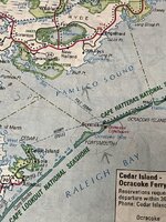
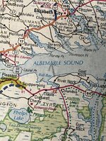
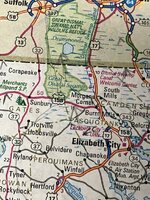
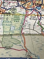
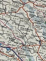
These pictures are from my Rand Mc Nally road atlas where I extrapolated the forecast track from the NHC over 6 plus days before Hurricane Isabel made landfall.

It’s written in pencil and the arrows are obviously the direction the storm was plotted out to.

The second arrow is just below Albemarle Sound in NC. The third arrow is just northwest of Elizabeth City. The next arrow is just south of Lake Drummond in the Dimal Swamp.

In the Virginia part you can see the arrow just below rte 14 in King and Queen county.

Score one for Team Hoarders … :LOL:

I like keeping the older ones… Wish I hadn’t lost that 1951 Rand Mc Nally atlas… That was in great physical condition. That was awesome to see how the roads were prior to the Dwight Eisenhower interstate system.
 

Attachments

  • IMG_0337.jpeg
    IMG_0337.jpeg
    268.2 KB · Views: 5
  • IMG_0334.jpeg
    IMG_0334.jpeg
    298.6 KB · Views: 4
  • IMG_0335.jpeg
    IMG_0335.jpeg
    272.1 KB · Views: 5
  • IMG_0340.jpeg
    IMG_0340.jpeg
    239.2 KB · Views: 4
  • IMG_0338.jpeg
    IMG_0338.jpeg
    236.7 KB · Views: 7
  • IMG_0342.jpeg
    IMG_0342.jpeg
    166.8 KB · Views: 4
Last edited:
I’m enjoying reading all the input. I recall being at Disney World when a hurricane missed Florida entirely. There was no risk to anyone, however, it was cloudy. Simply put, who wants to spend a beach vacation in dismal cloudy weather. Take a look at the satellite photo of this thing. Notice the clouds extend way beyond the predicted “affected” area. However, if the excitement of being a hurricane chaser is appealing, go for it. ;)
 
Thank you again everyone for your advice. We planned a flight out tomorrow AM from Brandeton SRQ but that was just cancelled as the airport is closing and so is Tampa TPA at midnight. Not enough time to catch the last flight out as we predict the lines will be too long even though the flight is delayed.

We are en route to ATL to catch a flight out from there tomorrow AM or Noon.

I guess I could have planned this better but when we booked the tickets there was no indication of storms to a layperson such as myself.

The fact that the first part of this hurricane season was calm, despite the hot ocean temps, made me a little complacent I guess.


Photo from the beach around noon:
View attachment 175585
Good luck, tricky along the gulf coast to predict landfall so far in advance. As of today it looks like Sarasota will be fine. if I was in a modern condo or hotel I wouldn’t be the slightest concerned but a bungalow? Hmmmm … would need another 12 hours to know for sure or go to a hotel a little inland for the night, storm is moving by fast.

Difficult to make those decisions, stay or go within a narrow time frame
 
I’m enjoying reading all the input. I recall being at Disney World when a hurricane missed Florida entirely. There was no risk to anyone, however, it was cloudy. Simply put, who wants to spend a beach vacation in dismal cloudy weather. Take a look at the satellite photo of this thing. Notice the clouds extend way beyond the predicted “affected” area. However, if the excitement of being a hurricane chaser is appealing, go for it. ;)
After the storm the weather is usually perfect - the storm sucks all the energy and humidity out of the air. Of course the surf is still up, and you might be sitting in a pile of tinder, but if your only concerned with weather.
 
1693314519108.jpeg

Leaving ATL, one way trip rental fee was brutal at $356. Better safe than sorry or spending time on a windy and soggy beach. Plane is half empty.
 
If the track holds true, it won’t be anywhere near Sarasota. Also, as of right now and I stress right now, it’s just a little tiny hurricane size wise with a narrow band of wind. This is in the context of Sarasota meaning hurricane force winds will not touch the coast there.

When it does make landfall way north of there of course it won’t be pretty
 
While there is no significant weather near SRQ area, yet, just overcast with a very light breeze, it certainly is not vacation beach weather.

It also appears like many businesses/restaurants have shut down for the day, which no doubt will enrage those who are nowhere near here, and further entrench their externally planned, willfully embraced biases, as it keeps them anger scrolling.

Soon we will see the plastic picnic table chair meme with one chair tipped over tagged with 'we will rebuild' from those located outside the cone.
 
I hate to say this, but the Siesta Key area might have been safe. It looks like the Idalia track will go well north of there.

I hope so, wish no harm on those in Pasco County/etc., but the Longboat Key/Siesta Key areas and points south didn't need this storm hitting them right now.
 
Back
Top